• HOME
  • OUR WORK
  • Who
  • Photography
  • BLOG TYPE STUFF
  • Contact
ROAVR | Group

Aerial Filming Scotland. +44 (0)1463 667 302

  • HOME
  • OUR WORK
  • Who
  • Photography
  • BLOG TYPE STUFF
  • Contact

Muir burning, Scottish Borders - November 2017

As opportunistic as ever one of our teams spied some muir burning in Northumbria at sunset whilst returning to base and stopped to capture it.

To keep the heather moor in a good state of health, it is deliberately burned in a controlled fashion.  In the same way that healthy biodiversity depends upon having a healthy diversity of habitats (such as woodland, beaches, moors, marshes etc), a healthy diversity is also needed within each of those habitats themselves.  


Muir Burn
tags: muir burn, burning, fire, heather burning, heather burn, muir burning, northumbria, Northumbria
categories: Scenic
Friday 11.03.17
Posted by Matthew Harmsworth
 

Yankee Pier - Dalmore, October 2017

During WW1 the American Navy took over Dalmore Distillery and used it as a mine base.  

The so-called ‘Yankee Pier’ still juts out into the firth.  In the 1930s the RAF’s presence grew.  

Alness became a training base for flying boats.  In 1938 228 Squadron with Saro Londons and Stranraers came to the firth from Pembroke Dock and this was followed in October 1939 by 210 Squadron of Sunderlands and Catalina  Flying boats.  

By 1941 4C OUT was fully established at Alness with the officers based at Dalmore House and the ’tech site’ and repair and maintenance area at Alness Point becoming a very busy strategic point for training and North Sea surveillance.   Short Sunderlands had a crew of 13 and by 1942 the OUT was producing 22 trained crews a month.

Yankee Pier looking toward Nigg Energy Port.

Dalmore Pier

tags: Yankee Pier, Cromarty Firth, Invergordon, Nigg, Evanton, Alness, WW2, Flying Boast, Catalina, Sutherland
categories: Boat, Scenic, Industrial
Friday 11.03.17
Posted by Matthew Harmsworth
 

Autumn Colours, Strathnairn - October 2016

Strathnairn lies 8 miles South West of Inverness and borders the Monadhliath Mountains.

The Strath's borders reach to the south by Dunmaglass, following the River Nairn through Croachy, Brin, Farr and Daviot, finally ending near where the Clava Cairns and Culloden Battlefield lie.

Autumn came early this year and the colour has not lasted due to the periods of high winds.  Only the larch are retaining colour into November.


Autumn_Colours_Oct_2017 (5 of 12).jpg
Autumn_Colours_Oct_2017 (6 of 12).jpg
Autumn_Colours_Oct_2017 (7 of 12).jpg
tags: autumn, culloden, Culloden Battlefield, Clava Cairns, Strath Nairn, Farr, Inverness, Autumn Colours
categories: Scenic
Saturday 10.28.17
Posted by Matthew Harmsworth
Comments: 1
 

Blair Castle - September 2017

Blair Atholl's most famous feature is Blair Castle one of Scotland's premier stately homes, and the last castle in the British Isles to be besieged, in 1746 during the last Jacobite Rebellion.

The Castle was the traditional home of the Earls (later Marquesses, now Dukes) of Atholl. The Duke of Atholl is the only person in the United Kingdom allowed to raise a private army. This army, known as the Atholl Highlanders, conducts largely social and ceremonial activities, and primarily consists of workers on the extensive Atholl Estates.


Blair Castle.

tags: Blair Castle, Blair Atholl, Castle, Visit Scotland, Perthshire
categories: Scenic
Sunday 10.22.17
Posted by Matthew Harmsworth
 

Loch Ness - October 2017

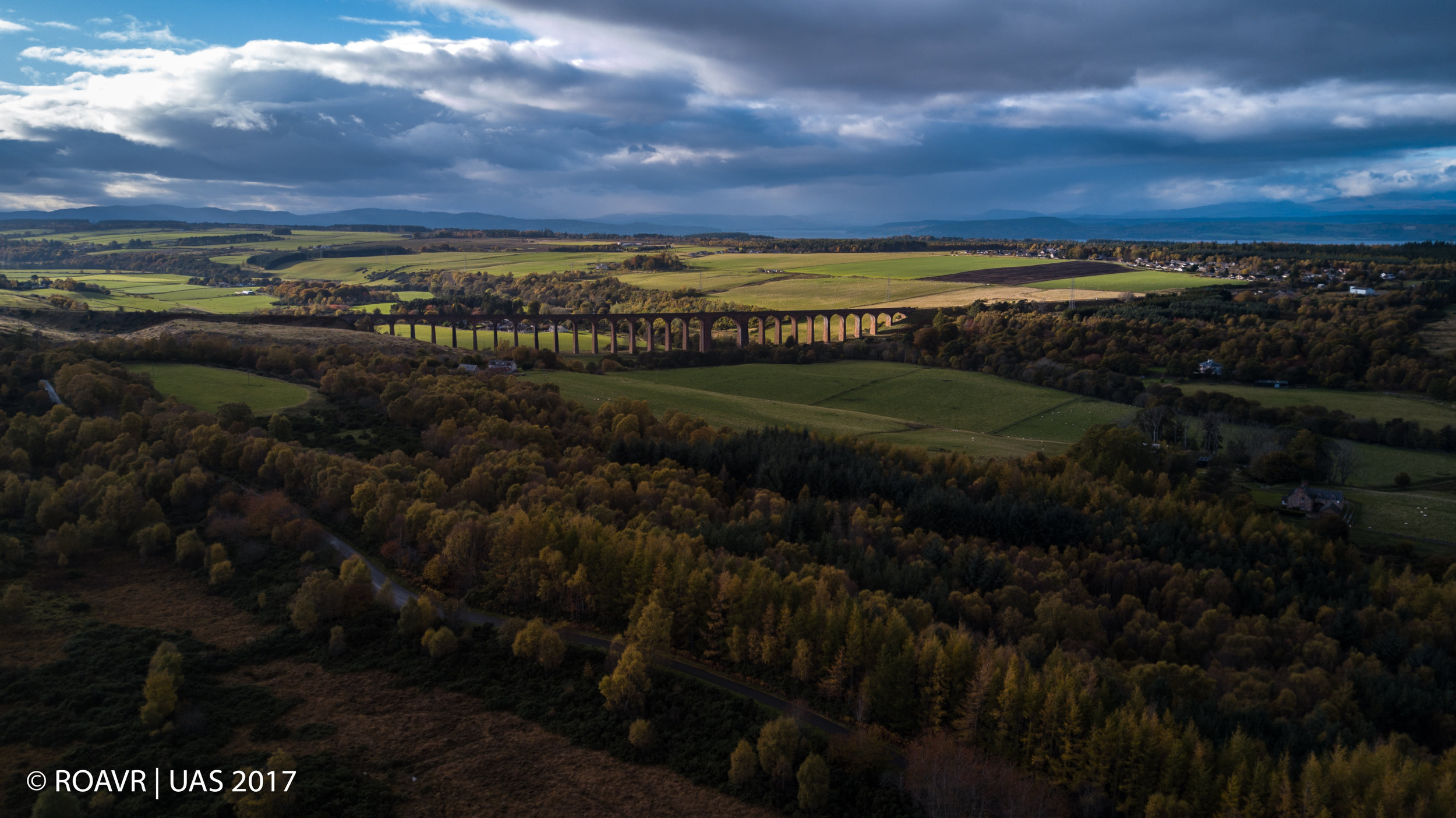
The magnificent Loch Ness.  Known across the world but actually one of the least impressive Scottish freshwater Lochs in our opinion.  And we have seen a fair few now!

Loch Ness is a large, deep, freshwater loch in the Scottish Highlands extending for approximately 23 miles southwest of Inverness.  Its surface is 16 metres (52 feet) above sea level.  Loch Ness is best known for alleged sightings of the cryptozoological Loch Ness Monster, also known affectionately as "Nessie".

It is connected at the southern end by the River Oich and a section of the Caledonian Canal to Loch Oich.  At the northern end there is the Bona Narrows which opens out into Loch Dochfour, which feeds the River Ness and a further section of canal to Inverness.  It is one of a series of interconnected, murky bodies of water in Scotland; its water visibility is exceptionally low due to a high peat content in the surrounding soil.

Loch Ness is the second largest Scottish loch by surface area at 22 sq miles after Loch Lomond, but due to its great depth, it is the largest by volume in the British Isles.  Its deepest point is 230 m; 755 ft making it the second deepest loch in Scotland after Loch Morar.  A 2016 survey claimed to have discovered a crevice that pushed the depth to 271 m (889 ft) but further research determined it to be a sonar anomaly.  It contains more fresh water than all the lakes in England and Wales combined and is the largest body of water in the Great Glen, which runs from Inverness in the north to Fort William in the south.


Loch Ness - Looking northeast.

tags: scotland, Loch Ness, Visit Loch Ness, Visit Scotland, Fort Augustus, Fort William, Caladonian Canal, Canal, Nessie, Loch Ness Monster
categories: Scenic
Sunday 10.22.17
Posted by Matthew Harmsworth
 

Aviemore - October 2017

The A9 'road to the Highlands' with Aviemore and the Cairngorms beyond.  The rising mists coming of the Lochs around the Rothiemurchus Estate can be seen clearly in this shot.

Aviemore is situated within the Cairngorm National Park.  The town is popular for skiing and other winter sports.  There are excellent views of the Cairngorms from various places within the town, especially from the railway station.


Aviemore - Cairngorm National Park

tags: Aviemore, Rothiemurchus, Rising mists, Mountains, Cairngorms, Cairngorm National Park, A9
categories: Scenic
Thursday 10.19.17
Posted by Matthew Harmsworth
 

Ben Nevis - October 2017

Corpach  is a large village north of Fort William, in the Scottish Highlands. The canal lock at Corpach Basin on Loch Linnhe, east of the narrows leading to Loch Eil, is the western sea entrance of the Caledonian Canal.

Dominating the scene is the highest mountain in Scotland, Ben Nevis at 4411 feet above sea level with Fort William to the right of the shot.


Corpach, Fort William and Ben Nevis.

tags: Fort William, Ben Nevis, Corpach, Caledonian Canal, Loch Linnhe, Loch Eil, Lock, Sea Lock
categories: Scenic, Boat
Thursday 10.19.17
Posted by Matthew Harmsworth
 

Cromarty - October 2017

Cromarty is a seaport on the southern shore of the mouth of Cromarty Firth, 5 miles seaward from Invergordon on the opposite coast. Until 1890 it was the county town of the former county of Cromartyshire.

The town grew around its port, formerly used by ferries, to export locally-grown hemp fibre, and by trawlers trawling for herrings. The port was a British naval base during the First World War and HMS Natal blew up close by on 30 December 1915 with heavy loss of life.

The port was home to Britain's smallest vehicle ferry, the Cromarty Rose, running across the Firth to Nigg.  The entrance to the Cromarty Firth is guarded by the Souters, two large cliffs that can be seen for many miles away and were previously fortified.

Cromarty - September 2017

tags: Cromarty, Sea, Visit Scotland, Nigg, Global Group, Souters, South Souter, North Souter
categories: Scenic, Boat
Saturday 10.14.17
Posted by Matthew Harmsworth
 

Muirtown Basin, Inverness - October 2017

Muirtown Basin is a large port area on the Caledonian Canal just above the first (sea) Lock where the Caledonian Canal meets the Beauly Firth.

This area houses a small marina and is popular for waterspouts with local sea scouts being based nearby.

The Caledonian Canal begins at Clachnaharry, connecting to the Beauly Firth via a sea lock. The Far North Railway Line also passes through, crossing the canal on a swing bridge. Clachnaharry used to have a railway station. This station opened in 1869 on the Inverness and Ross-shire Railway, and was the first stop after leaving Inverness, but closed in 1913.

Clachnaharry Sea Lock.

tags: Clachnaharry, Caledonian Canal, Lock, Beauly Firth, Inverness, Muirtown Basin
categories: Boat, Scenic
Saturday 10.14.17
Posted by Matthew Harmsworth
 

Muirton Locks - Inverness, September 2017

An expansion of the Caledonian Canal close to its northeastern termination, the Muirtown Basin lies between Clachnaharry and Muirtown a mile  northwest of Inverness city centre.

Planned in the early 19th century as a second harbour for the city by the canal's engineer Thomas Telford, it could not cope with the size of ships which were soon in use and thus never fulfilled its potential. It now serves as a marina. Immediately to the south of the basin are the Muirtown Locks, a flight of four locks on the Caledonian Canal at Muirton. The Muirtown Swing Bridge crosses the canal immediately to the north.

Muirtown Locks. 

Muirtown Locks. 

tags: Muirtown, Caledonian Canal, Visit Scotland, Visit Loch Ness, Beautiful Inverness, Canal, Loch Ness, Swing Bridge
categories: Scenic, Boat
Saturday 10.14.17
Posted by Matthew Harmsworth
 

Dingwall - September 2017.

Dingwall is a town and a royal burgh in the Highland council area of Scotland.  It was formerly an east-coast harbour but now lies inland. Dingwall Castle was once the biggest castle north of Stirling. On the town's present-day outskirts lies Tulloch Castle, parts of which may date back to the 12th-century building. In 1411 the Battle of Dingwall is said to have taken place between the Clan Mackay and the Clan Donald.

Dingwall, Cromarty Firth.

Dingwall, Cromarty Firth.

tags: Cromarty, Dingwall, visit scotland, sunset, sea, scotland, Visit Scotland
categories: Scenic
Saturday 10.14.17
Posted by Matthew Harmsworth
 

Loch Broom - October 2017

Loch Broom (Scottish Gaelic: Loch Bhraoin, "loch of rain showers") is a sea loch located in northwestern Ross and Cromarty, in the former parish of Lochbroom, on the west coast of Scotland. The small town of Ullapool lies on the eastern shore of the loch.

This photo was taken high above the Corrieshalloch Gorge situated on the Droma River 20 km S of Ullapool. It is 1.5 km long, 60m deep and formed at the end of the last ice age by rapid erosion caused by meltwater. 


Loch Broom

Loch Broom

tags: Visit Scotland, Drone Scotland, loch broom, ullapool
categories: Scenic
Saturday 10.14.17
Posted by Matthew Harmsworth
 

Loch Droma - August 2017

Loch Droma is situated between Beinn Liath Mhor Fannaich and Am Fauchagachm, near Garve, Highland, Scotland.

It is linked to Loch Glascarnoch as part of the Conon Hydro-Electric Power Scheme. The River Droma rises from Loch Droma and runs northwest to unite the Abhainn Cuileig to come of as the River Broom, which feds the Loch Broom. The summit of An Teallach can be seen from Loch Droma. From this loch starts the route up to Sgurr Mor, through a circuit up over Beinn Liath Mor Fannaich.


Loch Droma

Loch Droma

tags: Loch Droma, Loch Glascarnoch, An Teallach, Garve, Visit Scotland, Loch, Mountains
categories: Scenic
Thursday 10.05.17
Posted by Matthew Harmsworth
 

Loch Eck - September 2017

Loch Eck is a freshwater loch located on the Cowal peninsula, north of Dunoon, Argyll and Bute, Scotland.  It is seven miles long. Apart from Loch Lomond, it is the only naturally occurring habitat of the Powan (fish).

Loch Eck is within the Argyll Forest Park which, is itself part of the Loch Lomond and The Trossachs National Park.

The loch is also an impounding reservoir with a concrete dam measuring 0.870 metres high. The dam was completed in 1973. Loch Eck now supplies the freshwater to much of the southeast of Cowal, including Dunoon.

In July 2013, two dogs died due to algal bloom present in the loch. Warnings were then posted advising that people and animals should avoid contact with the water

Loch Eck

Loch Eck

tags: Loch Eck, Loch, Mountains, Cloud, Argyll, Visit Scotland, Explore Argyll
categories: Scenic
Thursday 10.05.17
Posted by Matthew Harmsworth
 

Culloden Battlefield - September 2017

Find out more about the events leading up to, during and after the Battle of Culloden at the new and award-winning visitor centre.

The battle lines have been redrawn at the new Culloden battlefield experience. With the site restored to as close as possible to that seen by the forces on that fateful day in April 1746, Culloden now welcomes visitors with an impressive new visitor centre and exciting interactive exhibition.

With over 1,200 dead in just one hour Culloden was a short but bloody battle - the last to be fought on British soil. Now all the family can experience and understand so much more about the events leading up to, during and after the battle. Follow characters who were actually involved in the battle around the interactive exhibition, experience the true horror of the battle in an immersive film, take a battlefield tour, and watch the daily Living History presentations which bring the battle to life.

The visitor centre also includes a range of environmentally friendly facilities, including a memorabilia shop and a restaurant with a variety of delicious meals.

https://www.nts.org.uk/Visit/Culloden


Culloden Battlefield

Culloden Battlefield

tags: Visit Scotland, Culloden, Culloden Battlefield, Jacobites, Inverness, National Trust Scotland, NTS
categories: Scenic
Thursday 10.05.17
Posted by Matthew Harmsworth
 

Conwy Castle, North Wales - October 2017

Conwy's massive military strength springs from the rock on which it stands.

Built for Edward I, by Master James of St George, the castle is amongst the finest surviving medieval fortifications in Britain. In a word, exceptional. You can’t fault it, from the grandeur of its high towers and curtain walls to its excellent state of preservation. An estimated £15,000 was spent building the castle, the largest sum Edward spent in such a short time on any of his Welsh castles between 1277 and 1307. Money well spent.

Conwy Castle

Conwy Castle

tags: Visit Wales, Conwy Castle, Conwy, North Wales, North Wales Castle, Castle, Llandudno
categories: Scenic
Thursday 10.05.17
Posted by Matthew Harmsworth
 
Newer / Older

ROAVR Group, Marr House, Beechwood Business Park North, IV2 3BW

+44 (0)1463 667 302